 The island is administered by the State of Tasmania, as is the other Bass Strait island to the east - Flinders Island. If you ask the locals on King, they will tell you that they relate more easily to Melbourne, believing that the powers in Tasmania have no real interest in them. I am not sure about that and saw plenty of evidence that Tasmania does assist considerably with the infrastructure on King.
We stayed on the southern end of the island at Grassy where until recently the main commercial activity was the Scheelite mines. Carol's sister and family lived and worked in Grassy in the 1970s and perhaps it was in part due to this that I took a closer interest in the island.
The island was not discovered by Europeans until 1797, but it was not until 1801 that Captain John Black in The Harbinger named King Island. An early interest was seal hunting which commenced as early as 1801. Today, King Island is better known for its quality beef................ ...............seafood (with the most amazing lobster/crayfish) and the dairy cows from whose milk they make delectable cheeses.
 The King Island Dairy seen from the air on the West Coast.
 ...............seafood (with the most amazing lobster/crayfish) and the dairy cows from whose milk they make delectable cheeses.
 The King Island Dairy seen from the air on the West Coast.
With only three and half days on the island, it was not possible to do full justice to the seafood delights available. In Currie especially, there was evidence of lots of fishing activity, including the Currie Harbour:
 Views of Currie Harbour with the lighthouse in the background
 And near the harbour, this delightful cottage that was shut! Very disappointing!
 Views of Currie Harbour with the lighthouse in the background
 And near the harbour, this delightful cottage that was shut! Very disappointing!
Grassy Harbour is now the main working port.... This view was just a few meters from where we stayed.
 This view was just a few meters from where we stayed.
 ........and it was from here that we began to explore the south and south-east coastline. I was really happy that there was a fair swell on the waters, as I cannot visualise King Island without a stormy sea.
 Only a mild sea, but fun to watch!
 In the late 1700s and in the 1800s, treacherous objects such as the rock above were not marked on the maps, neither were there lighthouses to protect shipping. The history of ships wrecked on the island will be on a separate chapter
 Looking the part and thoroughly enjoying the scenery, the walking and discovering many new things.
Red Hut Point (below) was a lonely beach, unspoilt and if the weather had been hot, very tempting for a swim. Not a person in sight. All for just us two to enjoy! The area around Seal Rocks was quite spectacular and we spent quite some time wandering around the coast line enjoying the quietness and beauty.
 The views at Seal Rock were well worth many photos - and we did!!!
 The area around Seal Rocks was quite spectacular and we spent quite some time wandering around the coast line enjoying the quietness and beauty.
 The views at Seal Rock were well worth many photos - and we did!!!
Nearby, there were the Calcified Forests. This was new to me and I wondered what it was all about.
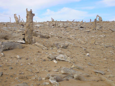 Just a small area in this reserve. Intriguing indeed!
The King Island Tourist information tells me that
'these remains are up to 7000 years old and are all that remain of an ancient forest, revealed when the lime-laden sand, which had covered and preserved the stumps has been exposed over the years from the constant Roaring Forties storms from the Southern Ocean.'
 Just a small area in this reserve. Intriguing indeed!
 Wallabies abound on King Island. Probably more than are desirable
 Seabirds overwhelmed us. See the 'fly-past' that they honoured us with!
 Even though it was in the middle of winter, it was good to see colour
in so may places

 Trees like that took both our fancy. Just so much character!
 Than scenes like this brings its own peace and reflection.
 But to get there was at times a bit of a challenge. The Corolla was up to the task even if it gave Jan some anxious moments!
The East Coast on King Island presented quite a contrast to the south coast with some idyllic beaches where a lone fisherman can fish his heart out. And yes, the big one did get away. I saw it and so did he. He was most unhappy, also because he lost his fishing gear.

 The beauty of this area was outstanding, including , what the map lists as the blowhole that included these delightful formation:
 And just around the corner, the following. Wow!
 Further north, King Island boasts some delightful lagoons.
The one below is Penny's Lagoon:
 The beach here remind me of what Lake Pedder was like before it was flooded:
King Island is well worth a visit. It's unspoilt beauty & tranquility is indeed good for the soul!
The final chapter is about the amazing ship-wreck history of King Island.
The final chapter is about the amazing ship-wreck history of King Island.
3 comments:
Hello Travelling Man... I am smiling broadly and re-living our trip... Q. where to now?
Very nice Siebrand thank you.
Heather & Geoff
looks lovely! i heard they are selling king island at "whole foods" here in the states - i do need to stop by sometime and see what they have (and how expensive it is!)
Post a Comment